
TEXAS STORMS
Updated by Henry Margusity
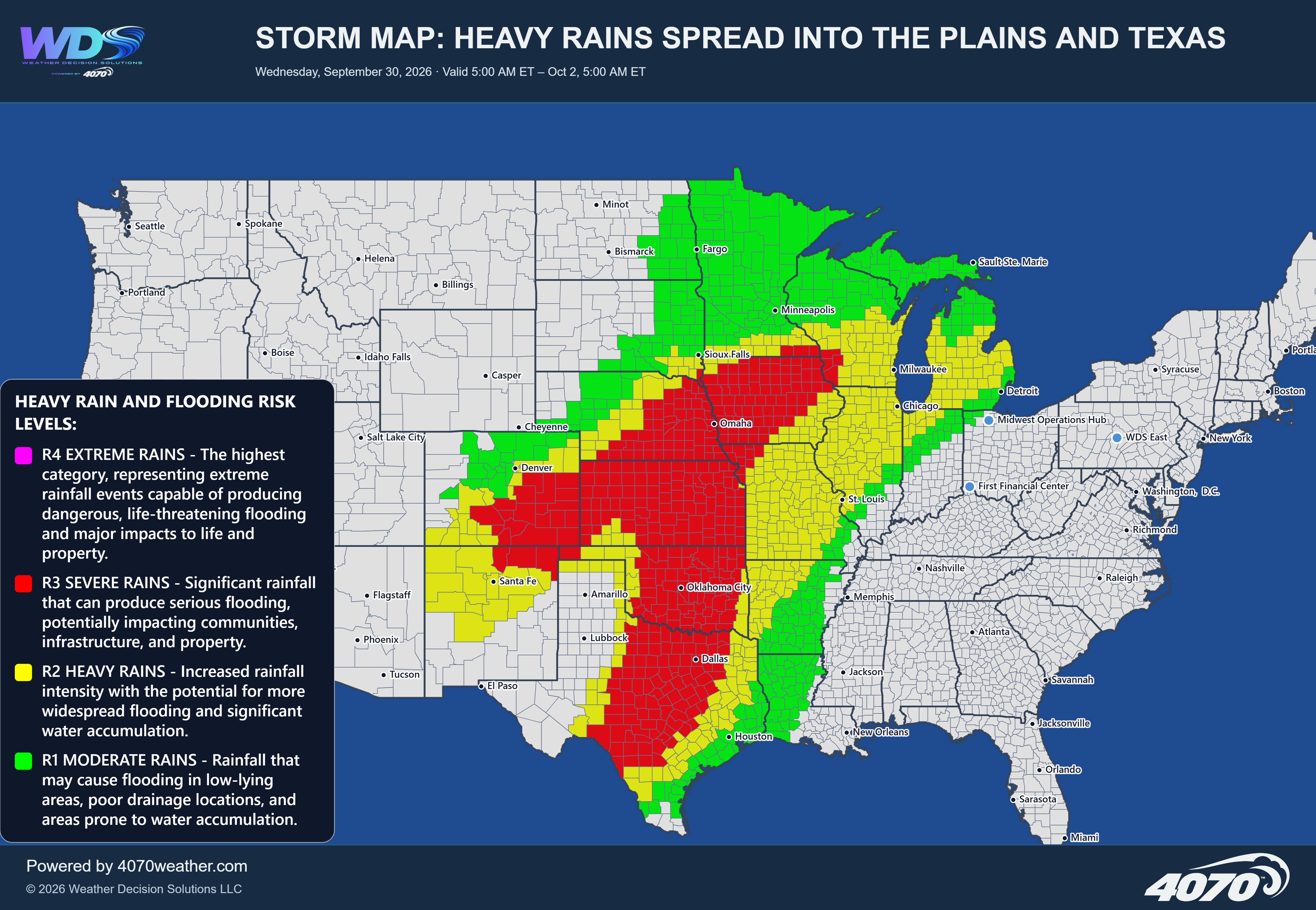
Storm Map: Texas-Style Storms Tonight and Sunday
A significant storm system will bring an increasingly active weather pattern across Texas tonight and into Sunday, with the potential for strong to severe thunderstorms, locally heavy rainfall, and damaging wind gusts. The greatest concern is across southern and southeastern Texas, where the 4070 Severe Weather Risk Map highlights the highest threat levels.
Storm Development TonightA developing area of low pressure across the southern Plains will help drive a strong frontal boundary south and east through Texas. Warm, moisture-rich air moving northward from the Gulf of Mexico will interact with this advancing boundary, creating an environment favorable for thunderstorm development.
Storms are expected to develop across portions of central and southern Texas, with activity potentially becoming more organized as it moves toward the Gulf Coast. Areas around Austin, San Antonio, Houston, and Corpus Christi will need to pay particularly close attention to changing conditions.
Severe Weather ThreatThe highest risk is concentrated across portions of southern Texas, including areas near Corpus Christi and the coastal region, where the map indicates a TS4 severe storm risk. This category represents the potential for damaging wind gusts exceeding 60 mph, hail larger than one inch, and a few tornadoes.
Farther north and west, a broader TS3 risk covers portions of central and south-central Texas. These storms could produce wind gusts exceeding 35 mph, heavy rainfall, small hail, and an isolated weak tornado.
A TS2 risk extends across a much larger portion of Texas, indicating the potential for gusty thunderstorms and locally heavy downpours. Even outside the highest-risk areas, storms could create hazardous travel conditions.
Heavy Rain and Localized FloodingIn addition to the severe weather threat, heavy rainfall will be an important concern. Some thunderstorms could produce intense rainfall rates, particularly where storms repeatedly move across the same locations. Urban areas and locations with poor drainage will be especially vulnerable to water accumulation and localized flooding.
Sunday OutlookStorm activity will remain a concern into Sunday as the frontal boundary continues moving across the state. The coverage and intensity of thunderstorms will depend on how quickly the front advances and how much warm, unstable air remains available ahead of it.
The greatest severe weather concern remains across southern and southeastern Texas, although additional thunderstorms could develop farther inland as the system progresses.
The Bottom LineThis is a weather situation that deserves attention across Texas tonight and Sunday. The combination of Gulf moisture, an advancing frontal boundary, and developing low pressure could produce a round of strong to severe thunderstorms.
The highest concern is across southern Texas, particularly near Corpus Christi and the coastal areas, where damaging winds, large hail, and a few tornadoes cannot be ruled out. Heavy rainfall and localized flooding will also be possible.
Residents should monitor weather alerts, have multiple ways to receive warnings, and be prepared to move to a safe location if severe thunderstorms approach.
Daily Storm Reports are free public forecast discussions from the WDS ops desk.
For full forecast coverage, visit the 4070 weather platform, the forecasts page, or the storm report archive.