
Snow Showers and Strong Winds Across the Great Lakes and Northeast
Updated by Henry Margusity
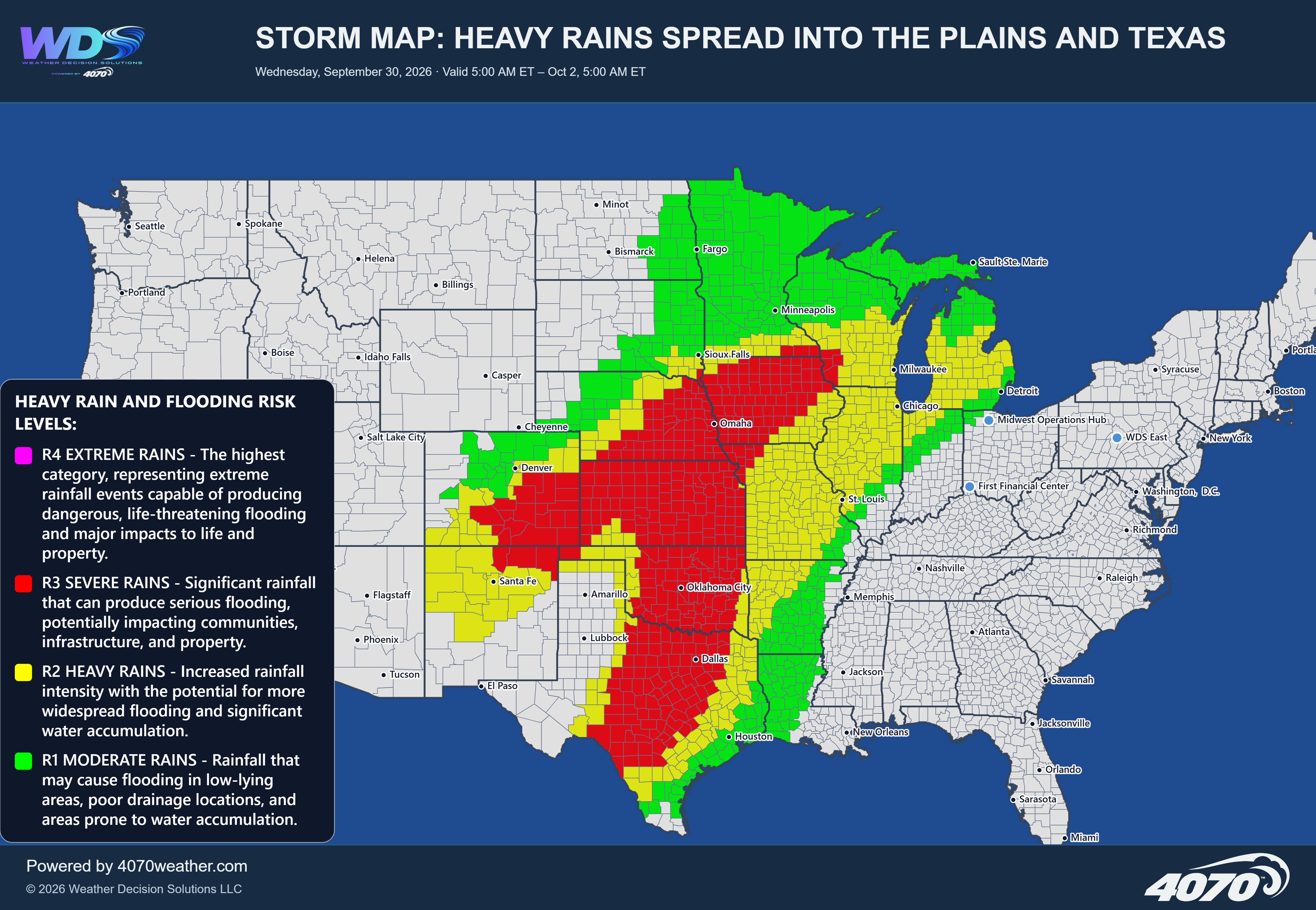

Storm Map: Heavy Rain and Flash Flooding Across the Southwest
A developing storm system is expected to bring periods of heavy rain across portions of the Southwest, with the primary focus on New Mexico and surrounding areas through Friday. Moisture moving into the region, combined with favorable conditions for showers and thunderstorms, could produce locally heavy downpours and a risk of flash flooding.
New Mexico: Main Focus for Heavy RainThe greatest concern is across central and southern New Mexico, including areas near Albuquerque, Santa Fe, Alamogordo, and extending south toward the Mexican border. The 4070 storm map highlights this region for locally heavy rainfall, with 1 to 3 inches of rain possible in a short period of time in the heaviest downpours.
Rainfall may not be uniform across the entire region. Some locations could receive relatively modest amounts, while stronger or slower-moving thunderstorms could produce considerably heavier rainfall over a short distance. This variability will be important because intense rainfall can quickly overwhelm drainage systems and generate rapid runoff.
Flash Flooding ConcernsFlash flooding is the primary hazard to watch. Areas with steep terrain, narrow canyons, normally dry washes, and low-water crossings are especially vulnerable. Water can rise quickly even when rainfall is occurring some distance upstream.
Localized flooding could also affect roads, urban areas, and locations with poor drainage. Drivers should be prepared for sudden changes in road conditions, reduced visibility, and water covering roadways.
Surrounding AreasThe rainfall threat extends into portions of southern Colorado and nearby areas of the Southwest. Showers and thunderstorms may develop around the broader storm system, although rainfall totals will vary considerably depending on storm coverage and movement.
Farther east into the Texas Panhandle and western Texas, the main heavy-rain focus appears more limited on this map. Conditions will depend on how far east the showers and thunderstorms spread.
What to WatchThe most important factors will be where the strongest storms develop, how quickly they move, and whether multiple rounds of rain affect the same locations. Repeated downpours would increase the risk of localized flooding, particularly where the ground cannot absorb water quickly enough.
Residents in flood-prone areas should monitor changing conditions and follow local weather alerts. Never drive across a flooded road or wash. Turn around, don't drown.
The Bottom LineThe primary concern through Friday is locally heavy rainfall across New Mexico, where the 4070 storm map highlights the potential for 1 to 3 inches of rain in a short period. Flash flooding is possible, especially in vulnerable terrain and areas with poor drainage. The exact location of the heaviest rainfall will determine where the greatest impacts occur.
Daily Storm Reports are free public forecast discussions from the WDS ops desk.
For full forecast coverage, visit the 4070 weather platform, the forecasts page, or the storm report archive.